|
||||||||||||||||||
|
|
||||||||||||||||||
|
| ||||||||||||||||||
| ||||||||||||||||||


Google Earth Tool for Bigfoot Reports: The BFRO.net Layers
|
|
||||||
|
Click on the links below to download BFRO.net Layers for Google Earth. You only need to install these layers one time in your Google Earth program, and they will automatically update themselves every time you launch Google Earth and periodically while you keep it open.
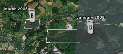
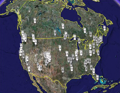
Google Earth is a free, downloadable software program that shows images of the Earth from the sky. Google Earth can show the landscape in three dimensions from any angle. It also allows the user to zoom in and fly through the landscape like a flight simulator. A Google Earth "layer" displays a set of geographic points overlayed on satellite imagery. The automatically generated BFRO.net Layers were created by Vaughn Hughes, a software engineer in Oregon, and are dynamically generated in real-time from the live BFRO.net database. IMPORTANT: When you first open the layers in Google Earth, you will not see many report icons. You must slide the Reports Timeline margin to the right to see more of the reports. Expand the timeline in both directions to see all the points for reports recently added to the BFRO database. If you click the footprint icons in the layers, it will show report details in a pop-up balloon. Request to witnesses: Please help us make these points more accurate. This Google Earth layer was made public in May of 2008. When we released it we knew some of the locations were not perfectly accurate, but we felt it would be easier and faster to correct the mistakes if we released the file to the public and asked witnesses to correct us where necessary. To correct a location for a report, you'll need to send us the correct Lat/Long coordinates in decimal degrees format. The Internet makes this very easy now. There is more than one free online mapping system that can quickly tell you the Lat/Long of a specific point on a map in decimal degrees (e.g. 33.504463, -117.649618) . One of those system is Yahoo Maps. To use Yahoo Maps to get the correct coordinates, go to Yahoo Maps then go to a map for a particular area, zero in enough to view the level of detail needed to determine where a particular incident happened. Move the cursor over the area/spot, right mouse button click and choose "Drive from here..." option. Once the option is selected, an "A" icon will display, hover over the "A" to get the Latitude & Longitude in decimal degrees of the location. Contact us, tell us the report number and the corrected Latitude & Longitude. |
 Click the links to the left to download the self-updating BFRO.net Layers. 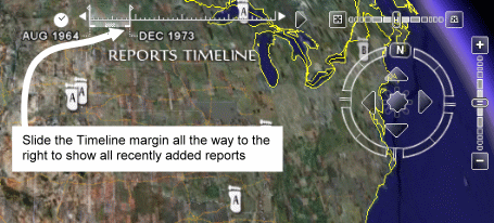 |
|||||
|
||||||