It is fashionable these days for writers and journalists to give
credit where credit is due, especially where due credit is not often expressed. Anderson Cooper made it fashionable. However most American journalists will still be reluctant to give credit to the Federal Government when it does things right.
Bigfoot researchers appreciate the acheivements
of the Fed more than most, so it's not inappropriate for us to give credit to the Fed where credit is due. Bigfooters utilitze that greatest monument of the Fed -- the interstate highway system -- to help us drive safely to the many wild and scenic places we love to explore. We also know that our most glorious inheritance as Americans -- our national parks and national forests -- were set aside and protected by the Fed.
Continuing with that theme, we give kudos to the Fed for a particular acheivement and resource that you won't hear about anywhere else. It's one of the rare things the Fed can elegantly stick in your face via the Internet and be very proud of.
You will use this web site, and you will like it, and you will appreciate the fact that the Fed runs it, and will keep it running.
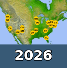
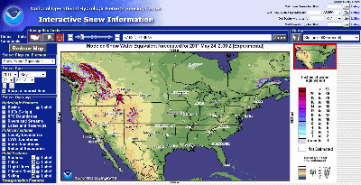
The Fed runs a "snow depth modeling" web site that could save your life someday, especially if you're a mobile-oriented person who likes to explore backroads of remote mountainous areas ... or if you're relying on a GPS to find a scenic route from Idaho to Las Vegas. The site allows you to zoom into particular areas, anywhere in the U.S. or southern Canada, to see where the snow is light and where it is deep. It helps you avoid routes that are snowed-in.
You can quickly find this web site if you can remember three words: interactive snow information. Those three words plugged into any search engine will pull up a link to the site.
Don't even try to remember the full name of the web site.
OK, I dare ya ...
It's the National Oceanic and Atmospheric Administration's National Operational Hydrological Remote Sensing Centers' Interactive Snow Information site.
Got all that?
"Interactive snow information" will suffice to get you there. This web site will never go belly-up. It will never ask you to register. It will never send you spam, and it will never infect your computer with a virus. The updated information it provides will always be honest and unbiased, and it will only get better
over time. The snow modeling data will only become more precise and granular.
Kudos.
One of the many awesome things about this web site is that you can bookmark a link for a particular view of a particular area and then check it periodically to see the snow receding or accumulating. You can see where there's only a few inches of snow, and where the snow is way too deep for a mini-van. You can see the snow well enough to avoid routes that may seem perfectly driveable according to your trusty GPS.
This Fed web site, combined with the expansive reach of the Verizon network, greatly increases the safe explorability of America.
Cell service is a critical component of safe explorability. For the past decade or so you could receive a cell signal along most stretches of most interstate highways, but nowadays you can get a cell signal and a broadband Internet connection far deeper into the off-highway terrain than ever before.
Verizon Wireless service is a special thing. It deserves special kudos. The reach of Verizon Wireless service cannot be fully realized or appreciated without a nifty little device called a Wilson cell phone booster (which also deserves kudos). Long used by cross-country truckers, these $200 devices greatly extend the reach of your cell phone and/or broadband Internet card ... no matter which service you use, and no matter whether its digital or analog.
For a long time I was dubious of Verizon's coverage map, until a few years back when I was traveling between Wyoming and Colorado along the spine of the Rockies. Before I got too deep into those mountains, I needed to get online to look at the Fed's snow depth site to make sure I would not get stuck in the snow on the way to Steamboat. But I was out in the middle of nowhere in Wyoming. Then I remembered previously zooming into the Verizon coverage map for the area along the WY/CO border. The interactive Verizon map showed a red blotch of coverage on a mountain ridge above a lonely paved highway along the border. So I drove up that highway and then drove up onto that ridge (completely off road) in my Land Rover (kudos to Land Rover) and was greeted by the familiar chime of my cell phone telling me that it had connected to cell service. It was only one bar though. Then I plugged in my Wilson cell phone booster and suddenly had four bars of cell & broadband service! I was able to acces the Fed's dependable snow depth site waaay waaay out in the middle of nowhere. I had no idea how far way the cell tower was, but it sure felt good knowing I could hit one if I could just get into a red blotch.
This is the only YouTube video demonstrating the capabilities of the Fed's snow depth site. It's a time-lapse of the snow depth changes in the eastern US over several days.
The Fed should take it upon itself to produce more YouTube videos demonstrating the many impressive things this site can do.
This Fed web site could have save a few lives in the western mountains over the past few months, had those victims been aware of it and used it before selecting their route.
If you're headed down from Canada in a mini-van and you're cutting across Idaho trying to navigate backroads to Las Vegas with your GPS ... you might think you'll be driving through some pretty dry terrain the whole way. But a quick check of the Fed's interactive snow information site may tell you otherwise.
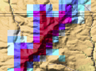
On the Fed site, zoom in on the area by dragging the cross hairs across the map to create a new square, of any size. The smaller the square, the further you will zoom in. The map resizes instantly after you draw the square.
If you can cross reference your road map with these snow depth modeling images then you can avoid snow on the backroads.
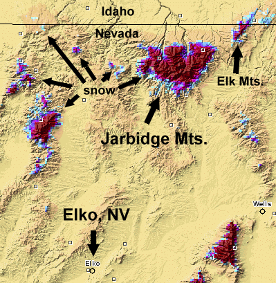
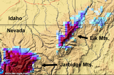
This is furthest you can zoom into the Elk Mountains. If you watch the snow come and go over time, you'll figure out the flanks of the range that allow you to quickly descend out of a snowstorm and into dryer terrain. Sasquatches prefer those flanks for the same reason you would. Moreover, if they hang just below the snow line they will always have clean water nearby, and they will keep pace with concentrations of ungulates and other mammals that also tend to relocate with the moving snowline.
Geography Note
If you ever need to drive somewhere where no one will hear you scream ... or if you don't want to see, or hear or smell a human being (or vice versa) for as a long as you can stand it ... then head straight to the Jarbidge Mountains of northern Nevada.
Northern Nevada and surrounding counties in neighboring states are the most uncrowded landscapes in the contiguous U.S. The largest national forest outside Alaska is scattered across this region. And it is the least visited national forest because it is so distant from services like hotels, food and gas stations (petrol stations).
Unless you have purposely looked for places out West that are completely devoid of humans, then you've probably never heard of this national forest: The Humboldt-Toiyabe Huge swaths of terrain among 13 desolate counties in Nevada and 6 forgotten counties in eastern California were set aside by the Fed for your pleasure. These public lands include several completely uninhabited mountains ranges.
The very short list of towns with services in this region would not exist but for the gold and silver mining industry (kudos to the gold and silver mining industry). And these two gas pumps in the tiny town mountain of Jarbidge (population 20) are the only gas pumps for a hundred miles or more in any direction.
Kudos to the Sinclair Oil Corporation of Utah for setting up those two gas pumps in Jarbidge, and kudos to the delivery guy who resupplies those pumps. If you run out of gas on a forest road off the beaten path in northern Nevada ... it could be months or even years before anyone finds you.
The largest mountain range in northern Nevada is the Jarbidge Mountains. There is definitely an old white settler legend of the "Jarbidge Monster" noted in some old texts. Indians never settled permanently in those mountains. Their name for the range may be a clue as to why. "Jarbidge" is an anglicized Shoshone indian word which translates to "monster that lurks in the canyon.". It is similiar to the Nez Perce indian word for "devil" so the Nez Perce may well have taken the word from the Shoshones.
Due to the lack of human visitors we don't expect to receive many sighting reports from those mountains, but due to the abundance of elk and deer, scattered families of sasquatches could thrive there as they do in other sky island ranges of the western U.S.