Geographical Index > United States > Minnesota > Cass County > Report # 14942
(Class B)
Submitted by witness on Wednesday, June 14, 2006.
County workers find possible footprints near Bena
(Show Printer-friendly Version)
YEAR: 2006
SEASON: Summer MONTH: June DATE: 6 STATE: Minnesota COUNTY: Cass County LOCATION DETAILS: right off hwy 2 in Bena. take a right onto six mile lake rd. NEAREST TOWN: Bena NEAREST ROAD: Six Mile Lake Rd. OBSERVED: A friend of my husbands works for the county and was grating the Six Mile Lake Road in Bena, MN and notice huge prints on the side of the road. The DNR has come out and made molds of the prints and I was just out there on 6/13/06 to see for myself. The prints look exactly like the molds from the 1960's on this site. The DNR does not know what it is but said only something that is 800-1000 lbs could make prints that deep in the dirt. They also found 30 prints back in the swamp area. The grass was laid out flat in some areas and I noticed the steps were short for someone that size, we were thinking that he was hurt as there was only a right foot print and every so often the grass would be laid flat, like he was falling down. ALSO NOTICED: My supervisor at work lives very close to the site and she said her dogs were barking and going crazy that night. OTHER STORIES: There are many people up here that have stories but none as far as I know have reported anything.
Follow-up investigation report by BFRO Investigator B.G. Martin:
I was able to speak to C.F. the county worker on the phone and ask him what he observed.
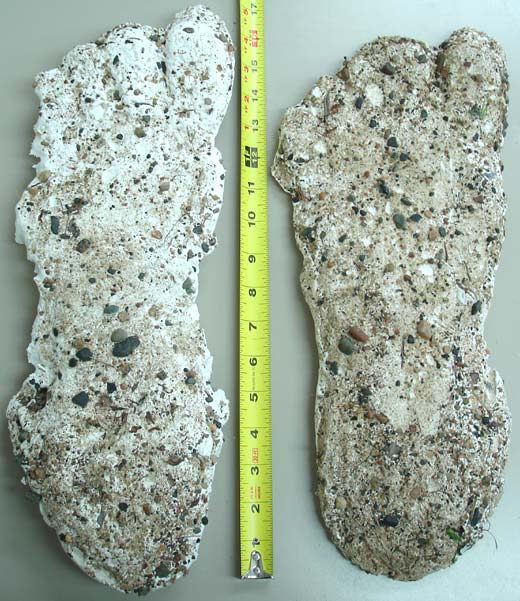
It was Tuesday, June 6th at 11:50 am when C.F. was grading 6 Mile Lake Rd., moving south at just under 3 miles an hour when he observed what he thought were bear tracks in the gravel road below him. He destroyed 3 4 tracks before he got out of the Caterpillar (140H) road grader to have a closer look. Upon inspection, he found a total of 16 to 18 tracks; each was 17 to 18 inches long, covering 60 feet with a 4 1/2 foot stride length. The heel of the foot was 5.75 inches wide, and ball of the foot was 6.75 inches wide. He could see that it was a heel to toe motion, and there werent any dermal ridges visible in the tracks. The tracks appeared to come out of the Tamarack swap on the west side of the road and went south, but he couldnt see the exactly spot where it exited the swamp. Half the tracks were on the gravel road (Hard pack) and the other half were on the soft shoulder of the road. The tracks in the relative soft shoulder were 1.5 inches deep. The tracks on the Hard pack only showed the heel and ball of the foot and werent nearly as clear as the deeper imprinted tracks. He said the last track look like it was oriented to go across the road to the east.
He was asked, How likely do you think the tracks were faked. He responded, Its very unlikely they were faked, because; why not put the tracks in an area where there are more people. The nearest human habitation is 3 4 miles away; its a resort on a lake. C.F. has 21 years hunting experience and was certain the tracks werent made by any animal he knew of that lives in the area.
Background Information:
C.F. re-grades 6 Mile Rd. every 2 ½ weeks to 3 weeks; he makes two passes on the road. When he made his observation it was 68 degrees out. He remembered that it rained the day before, and it rained a quarter inch. The last soaking rain before that was 24 days before, rained half an inch.
This incident happened 2 weeks before the sighting (Report #17545)
on Hwy 2. Sighting #17545 is 9.75 miles directly east of this incident.
About BFRO Investigator B.G. Martin:
Investigator Since 2006
|