| BFRO Home | Reports Database | New Report Additions | FAQs | ||||||||
| Media Articles | Hypotheses & Projects | About the BFRO | |||||||||
YEAR: 2014
SEASON: Winter
MONTH: February
DATE: 2-4-14
STATE: Ohio
COUNTY: Scioto County
LOCATION DETAILS: North end of State Rest area, NW qaudrant
NEAREST TOWN: Piketon, OH
NEAREST ROAD: SR 23
OBSERVED: 2-4-14: 4 miles south of Piketon, OH at State Rest Area (north end) after 12" overnight snow. Stopped by rest area at 1600hrs to let dog out (Rhodesian Lab). Followed septic area fence line to towards back of area, turned north only to discover tracks in (3) path's from 5-7' spread. BFRO was immediately contacted with Investigator Marc from Cleveland contacting me about the incident (he has field info.). I returned to area 2-7-14 at 1330hrs & took numerous photos using items for scaling purposes. A possible nest was also found at north end near ravine & wood line, again given to Marc at BFRO. Marc returned call last night (2-7-14) saying his contact visited the area, found prints & documented spread & locations. The field personnel were to return again today (2-8-14) to cast prints where toes were visible. There was no way any other North American animal could've produced these tracks at 15.5" & 5-7' increments. I have several quality photos now that depict the event.
ALSO NOTICED: Numerous quality tracks & are being cast by Ohio BFRO members according to Marc from Cleveland
OTHER WITNESSES: My dog Lucy (picked up scent)
OTHER STORIES: No. Never been there before. I'm from Oklahoma
TIME AND CONDITIONS: 1600hrs w/ 12" new snow on ground
ENVIRONMENT: snow covered grass area behind 6' stockade fence area
Follow-up investigation report by BFRO Investigator Bea Mills:
The BFRO initially received a phone call, Marc DeWerth returned the call and a report was submitted.
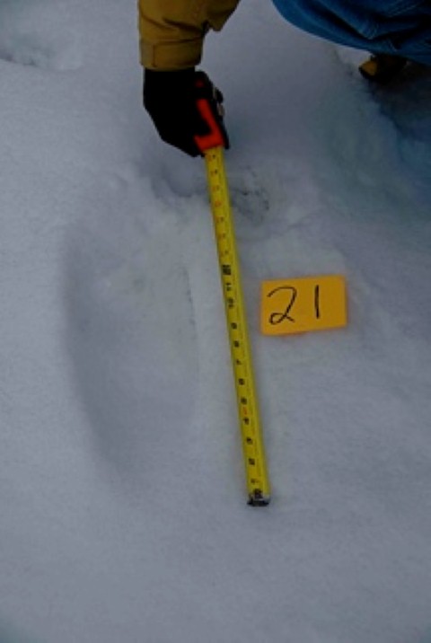
The witness took several photos, this is the only good one, unfortunately not much detail can be seen. I asked him how he measured the tracks and he told me he's been working with the railroad system for a long time and he is really good at looking at something and being able to come up with an accurate measurement.
A site visit was performed on 2/7, by myself.
The results of this visit led to a follow-up investigation on 2/8 with Investigator Mark Maisel and myself.
A conference call interview was conducted with the witness on 2/10, included were Mark Maisel, Marc DeWerth and myself. We found the witness to be credible in his accounts. The following can be added to this report.
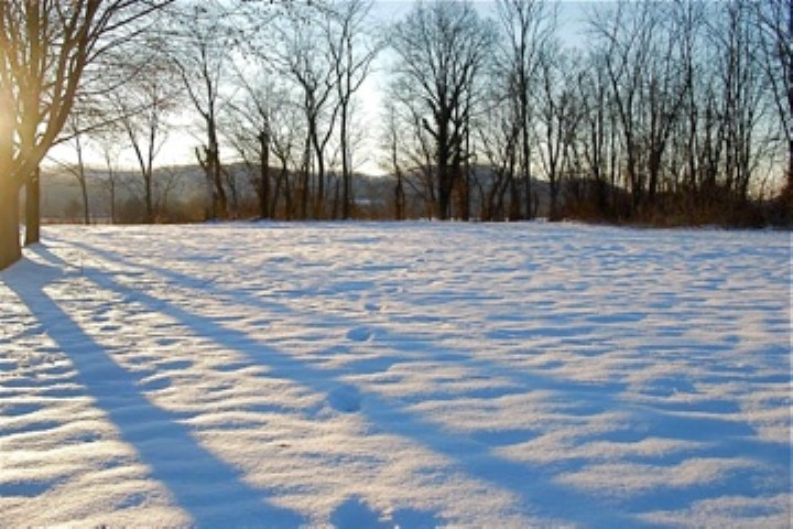
I arrived at the site location on 2/7 for initial followup, while on a conference call with Ohio BFRO Investigators, Marc DeWerth and Mark Maisel during the entire visit. Noted was witness' description of site. Observed were 2 separate, distinct track lines in the area. Also noted were dog tracks and boot tracks left by the witness as stated. All prints were able to be differentiated between the witness and dog, and myself.
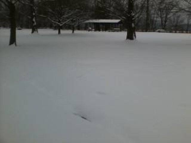
Photo of the trackline I observed on 2/7 at approx. 5:30 p.m. -
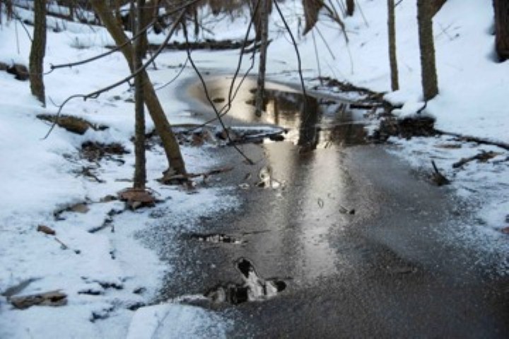
Walked into creek area, where possible tracks (secondary to freezing/thawing) were observed in the frozen areas of the creek way. Photo of the creek -
Follow-up investigation occurred on 2/8, arriving on scene at 10 a.m. Upon arrival, we walked the perimeter of the location, observing both track lines and the surrounding area. Noted were other human prints in area. Documentation of both track lines was conducted.
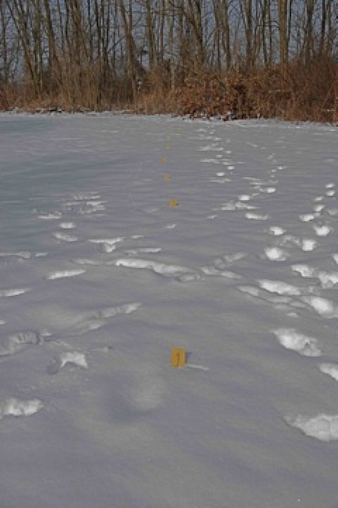
We identified each individual print of trackway #1 which consisted of 8 prints, with the second print (in sequence) which had been destroyed prior to our arrival.
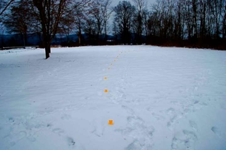
Trackway #1 (labeled in succession 1-8) -
Trackway originated coming out of a 10ft. ravine, which has a small running creek. Upon exiting ravine, tracks headed in a Southeast direction, towards the rest stop's fenced in water treatment area. A 6ft. high, stockade fence surrounds that area.
We then proceeded to document trackway #2, which consisted of 23 successive tracks of which the 22nd track was partially destroyed. A photo was taken of an indistinct track which we believe was track #22 in this sequence.
Trackway #2 (labeled in succession 1-22) -
This trackline proceeded from the water treatment area, heading to the Northwest into the ravine, roughly paralleling Trackway #1. From the #2 trackway into the ravine, no discernable prints were observed.
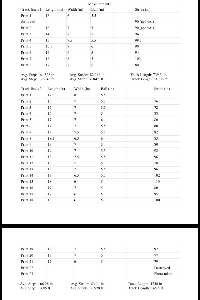
The following chart notates measurements of all tracks observed, including track size, stride (methodology- heel to heel), step (the addition of two stride lengths) -
Findings during our investigation included:
1) 136 photos taken.
2) Approx. ½ mile to the Scioto River thru a cut cornfield.
3) Ravine frozen over on 2/8 investigation, though showed possible tracks on 2/7 investigation.
4) Railroad tracks approx. 1500 ft. from tracks.
5) Several lines of high tension wires noted.
6) Across the river, stocked feed barns & farm animals noted.
7) Across the highway, elevation change of approx. 200ft. Going into more forested areas.
8) Across the river, elevation change noted to be between 300-400ft higher into forested areas.
9) Farmland surrounding the location.
10) Trash cans noted to have trash in them on site.
11) Fence surrounding water treatment area approx. 6ft. in height.
12) Ravine depth approx. 10ft.
13) Unable to scout further into fields due to hearing gun shots.
14) Elevation change between rest stop and lower fields approx. 15 feet.
15) Whatever made the tracks came in from the ravine heading to the SE, turned around and headed out approx. NW.
16) Thirty-two steps noted of which, 2 were destroyed.
17) Numerous deer tracks were in the area.
18) An abundance of rabbit tracks were seen.
19) Dog and human prints also noted.
20) After the original find, winter (ice/snow) storm deposited up to 9 inches in snow accumulation.
21) Date of initial follow-up, creek partially flowing and possible tracks noted in the creek.
22) Date of investigation, creek frozen over, signs of previous tracks were obliterated.
23) Rest stop is not high traffic, in the 2.5hrs, less than 20 vehicles were noted and 1 semi-truck.
24) To the north and west, farming fields were noted.
25) Several miles to the north, a quarry area was noted.
26) The area is approx. 15ft. above the field to the west with the ravine and creek acting as a run-off towards those fields.
Upon further investigation, west of the river, the following was also noted.
- A couple of high tension power lines traversed the area.
- Farms with livestock in the area.
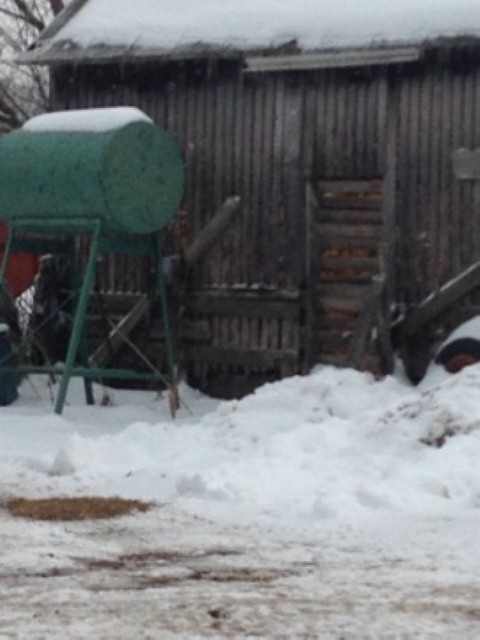
- Stocked feed barns (as noted in this photo) were present.
- Wayne National Forest is to the SE.
- Shawnee State Forest is to the SSW.
- The area on either side of the highway is punctuated by hills and forests.
Unfortunately because of the increment weather that passed through the area before we had a chance to investigate, and a warm-up, the detail of the tracks described initially by the witness were lost so casts were not made.
About BFRO Investigator Bea Mills:
Bea Mills is an avid outdoors woman currently working in the medical field. A Certified Volunteer Naturalist for Ohio, primarily in the Hocking Hills region, and promoter of education and conservation of natural areas in Ohio.